The United States of America is a vast and diverse country, known for its rich history, cultural variety, and breathtaking landscapes. One of the best ways to understand this great nation is by exploring its map. From coast to coast, the USA map offers a snapshot of fifty states, each with unique identities, landmarks, and stories. In this comprehensive guide, we will explore the layout of the USA map, key geographical regions, major cities, and the significance of understanding the map in travel, education, and more.
Understanding the Basics of the USA Map
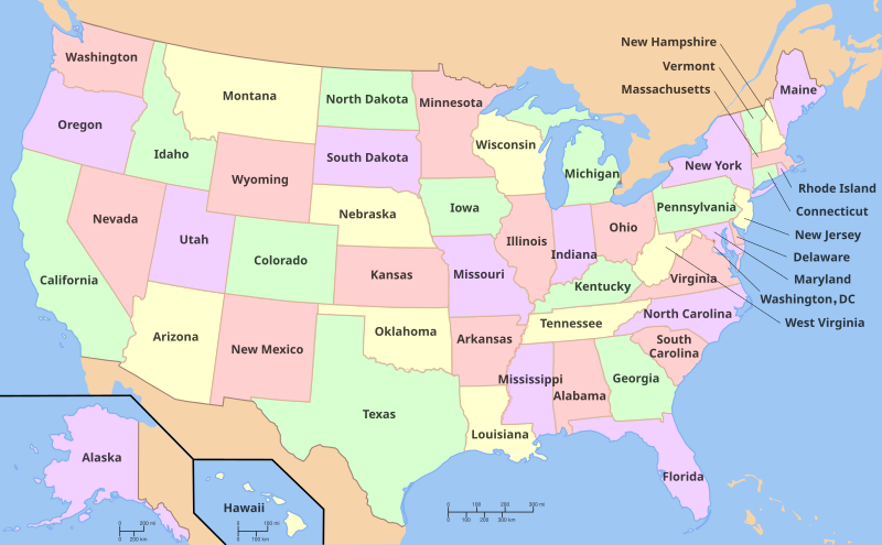
At its most basic level, the map of the United States displays the 50 states, including the mainland and two non-contiguous states: Alaska and Hawaii. The country stretches across 3.8 million square miles, making it the third-largest nation by area.
The USA is bordered by:
-
Canada to the north,
-
Mexico to the south,
-
Atlantic Ocean to the east, and
-
Pacific Ocean to the west.
In addition to the states, the map includes several U.S. territories such as Puerto Rico, Guam, and the U.S. Virgin Islands.
Geographic Regions of the United States
The United States is often divided into five major geographic regions, each with distinct features and cultural elements.
1. Northeast
This region includes states like New York, Massachusetts, and Pennsylvania. It’s known for its historical significance, as many events of the American Revolution occurred here. Cities like Boston, New York City, and Philadelphia are cultural and economic hubs.
2. Midwest
Often referred to as “America’s Heartland,” the Midwest includes states like Illinois, Ohio, and Michigan. It is known for agriculture, manufacturing, and being home to the Great Lakes. Chicago, the largest city in this region, is a major center for architecture and commerce.
3. South
The South is characterized by its warm climate, hospitality, and rich cultural heritage. States include Texas, Georgia, and Florida. From the beaches of Miami to the live music of Nashville, the South is vibrant and diverse.
4. West
This region includes mountainous states like Colorado and desert landscapes like Arizona. California is a standout state in the West, known for Hollywood, Silicon Valley, and scenic coasts.
5. Pacific Northwest and Alaska
While part of the West, the Pacific Northwest (Oregon and Washington) and Alaska are often discussed separately. This area features lush forests, majestic mountains, and abundant wildlife. Alaska, located northwest of Canada, is the largest state by area.
Key Features of the USA Map
When analyzing the USAmap, several features stand out:
🌍 Interstate Highway System
The extensive network of highways connects all major cities and regions, making road trips a popular American tradition.
🗺️ Time Zones
The USA spans six time zones: Eastern, Central, Mountain, Pacific, Alaska, and Hawaii-Aleutian.
🏞️ National Parks
The USA map is dotted with over 400 national parks and monuments, including Yellowstone, Grand Canyon, Yosemite, and Great Smoky Mountains.
🏙️ Major Cities
Understanding the location of major cities on the map is essential. Some of the most prominent include:
-
New York City (NY)
-
Los Angeles (CA)
-
Chicago (IL)
-
Houston (TX)
-
Phoenix (AZ)
-
Seattle (WA)
-
Washington D.C. – the nation’s capital, located between Maryland and Virginia
The Importance of the USA Map in Education
Maps are a crucial educational tool in schools across the country. They help students:
-
Understand state locations and capitals
-
Learn geographic literacy
-
Explore migration patterns and historical boundaries
-
Develop a sense of spatial awareness
Interactive maps and digital tools now allow students to explore the USA map in new and engaging ways.
Using the USA Map for Travel Planning
The USA map plays a vital role in travel and tourism. Whether you’re planning a cross-country road trip or visiting a specific region, a map helps you:
-
Choose the best routes
-
Discover nearby attractions
-
Understand distances between destinations
-
Identify climate zones and terrain types
Popular travel routes include:
-
Route 66: from Chicago to Los Angeles
-
Pacific Coast Highway: along the California coastline
-
Blue Ridge Parkway: through the Appalachian Mountains
Fun Facts About the USA Map
Here are some interesting tidbits that bring the USA map to life:
-
Texas is larger than any country in Western Europe.
-
Alaska is so big that it can fit Texas, California, and Montana inside it.
-
Rhode Island is the smallest state, just 1,214 square miles.
-
The geographic center of the continental USA is near Lebanon, Kansas.
-
Four Corners Monument is the only point in the USA where four states (Arizona, New Mexico, Utah, and Colorado) meet.
Digital Mapping and Modern Technology
Modern tools like Google Maps, Apple Maps, and GIS systems have revolutionized how we interact with maps. Now, users can:
-
View satellite imagery
-
Get real-time traffic updates
-
Explore terrain in 3D
-
Navigate using GPS while traveling
These tools make the USA map more accessible and useful than ever before.
Tips for Reading the USA Map
If you’re new to map reading, here are some tips to get you started:
-
Use the compass rose to identify directions (North, South, East, West).
-
Refer to the legend for map symbols.
-
Understand scale to estimate distances between cities.
-
Recognize state boundaries and capitals, usually marked with stars.
Conclusion
The map of the United States is more than just a collection of borders and names—it’s a gateway to understanding the country’s identity, diversity, and history. Whether you’re a student, a traveler, or just a curious mind, exploring the USA map can open doors to deeper knowledge and exciting adventures.
From the snowy peaks of Alaska to the sunny beaches of Florida, every corner of the USA has a story to tell. Grab a map and start your journey today!